Posts tagged natural hazard
Resources to Help Learners Understand the 2011 Tohuku Earthquake and Tsunami
Mar 19th
Almost all of these resources have been linked to by educators using Twitter, and should help learners to deepen their understanding of the disaster that occurred on 11th March 2011, and its aftermath.
Note on reliability: These resources were collected here on 20th March 2011 and so only include information available on or before that date – learners are advised to research for the latest updates as well, as the situation reported on in these links is always changing and a lot more information continues to be made available.
Excellent slideshow by Simon Jones providing questions to prompt thoughtful reflection by students learning about the disaster:
How Shifting Plates Caused the Earthquake and Tsunami in Japan: Interactive map by The New York Times helps explain the tectonic causes of the earthquake and tsunami.
Japan Earthquake 2011 Google Map provided by Google with many possible placemarks to explore on the left side of the map.
For Google Earth – ‘post-event imagery of several affected areas in Japan’ [View these files in Google Earth]
Striking before and after satellite imagery of various locations in North Japan hosted on the NY Times. Drag the slider from left to right and back to see the differences. A similar resource has been posted by the Guardian.
In pictures: Japan earthquake and tsunami – slideshow hosted on BBC website
Slideshow – Seven Days in Japan – 70 photographs each with a caption underneath.
Japan: the day after the earthquake and tsunami – in pictures – slideshow hosted on the Guardian newspaper’s website.
Factbox: Japan disaster in figures – published by Reuters on Saturday 19th March.
A graphic representation of the earthquake and resulting tsunami – useful to understand the causes. Provided by the National Post.
2011 Tōhoku earthquake and tsunami – Information collected on wikipedia.
Interactive map by the Guardian’s website, as at 16th March 2011 (note: information on nuclear risk likely to change quickly – learners are advised to research for the latest updates on this, as the situation has been continually changing).
JPquake Journalist Wall of Shame – Interesting ‘crowd-sourced’ wiki created by people concerned that some reports on the disaster contained bias, speculation, misinformation and sensationalism. This could be interesting to students of IB Theory of Knowledge, as well as other subjects.
100+ Teaching Resources About The Japan Crisis by edudemic.com – Several resources linked to above are also included in this very useful collection. The collection also provides a lot more links on the science behind the disaster.
A powerful video created by students at Yokohama International School:
Tohoku Japan Earthquake Awareness from 12ShirotsukaM on Vimeo.
The NY times has invited teachers to share ideas on how they and their students have been responding to the disaster. Recommended.
Japan Quake Map – Based on Google Maps, this is revealing, dynamic time-lapse map shows the sheer volume of seismic activity (earthquakes, pre-shocks and aftershocks) around North Japan beginning on the 11th March to current date (true at 31st March when this was updated).
Japan’s Earthquake & Tsunami: How They Happened – via openculture.com, a link to an informative 47 minute documentary

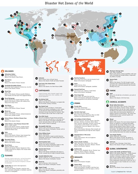
A Map of Major World Disaster ‘Hot Zones’
Dec 11th
This map could inspire some interesting discussion about the distribution of different major disasters. Click on it see the larger version.
Image: Stephanie Fox, io9.com original link


